MedwayM2BridgeCloud0169.JPG
From Warlike

Size of this preview: 800 × 600 pixels. Other resolutions: 320 × 240 pixels | 640 × 480 pixels | 1,024 × 768 pixels | 1,280 × 960 pixels | 2,016 × 1,512 pixels.
Original file (2,016 × 1,512 pixels, file size: 723 KB, MIME type: image/jpeg)
Summary
| Description |
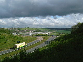
The M2 junction 2 entry roundabout on the A228 and the M2 Motorway Bridge and the Channel Tunnel Rail Link Bridge crossing the River Medway, viewed from Merrall's Shaw, Ranscombe Farm, Cuxton. On the far bank we see Borstal, Fort Borstal and the motorway snaking up the Nashenden Valley while the rail link proceeds in a more direct line.
|
||||
| Date | |||||
| Source | Own work | ||||
| Author | ClemRutter |
Attrib to Clem Rutter, Rochester,Kent.
Licensing
I, the copyright holder of this work, hereby publish it under the following licences:

|
Permission is granted to copy, distribute and/or modify this document under the terms of the GNU Free Documentation Licence, Version 1.2 or any later version published by the Free Software Foundation; with no Invariant Sections, no Front-Cover Texts, and no Back-Cover Texts. A copy of the licence is included in the section entitled GNU Free Documentation Licence. |
| This file is licensed under the Creative Commons Attribution-Share Alike 3.0 Unported licence. | ||
| ||
| This licensing tag was added to this file as part of the GFDL licensing update. |
This file is licensed under the Creative Commons Attribution 2.5 Generic licence.
- You are free:
- to share – to copy, distribute and transmit the work
- to remix – to adapt the work
- Under the following conditions:
- attribution – You must give appropriate credit, provide a link to the licence, and indicate if changes were made. You may do so in any reasonable manner, but not in any way that suggests the licensor endorses you or your use.
You may select the licence of your choice.
File history
Click on a date/time to view the file as it appeared at that time.
| Date/Time | Thumbnail | Dimensions | User | Comment | |
|---|---|---|---|---|---|
| current | 23:02, 8 May 2007 | | 2,016 × 1,512 (723 KB) | wikimediacommons>ClemRutter | == Summary == {{Information |Description= The M2 junction 2 entry roundabout on the A228 and the M2 Motorway Bridge and the Channel Tunnel Rail Link Bridge crossing the River Medway, viewed from Merrall's Shaw, Ranscombe Farm, Cuxton. On the far bank we s |
File usage
There are no pages that use this file.